GOM - the Global Overlay Mapping System
Layer Notes - Relief Map
 The images used for the relief map overlays were generated using the world-coverage GTOPO30 dataset, and the 3DEM software package. For more information, see the Software Used or Datasets Used pages. A set of 145 image tiles were generated, each 20° x 20°. (If you are wondering why the number is not 9x18=162, the answer is that 17 of the areas contain no land.) The tiles were joined together to make seamless continental images, and then re-sized and cropped to fit the map overlays. The images used for the relief map overlays were generated using the world-coverage GTOPO30 dataset, and the 3DEM software package. For more information, see the Software Used or Datasets Used pages. A set of 145 image tiles were generated, each 20° x 20°. (If you are wondering why the number is not 9x18=162, the answer is that 17 of the areas contain no land.) The tiles were joined together to make seamless continental images, and then re-sized and cropped to fit the map overlays.
Note: For those interested, the tiles will soon be available for free download on the MapAbility.Com website.
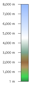
The colors chosen were designed to give a clear idea of elevation changes without appearing excessively false. A key to the colors used, and the elevation values that they represent, can be seen on the right.
|