|
These ITU Zone maps are suitable for the 'IARU HF Championships', a popular Amateur Radio Worldwide Contest, and other ITU zone-hunting awards and competitions. They show Zone 06, 07, and 08 borders to ARRL Definitions. You are welcome to use them on your own NON-COMMERCIAL website, if you include a link to this site, and DO NOT edit them in any way. Please Contact Me for other uses, sizes, styles, formats, or projections.
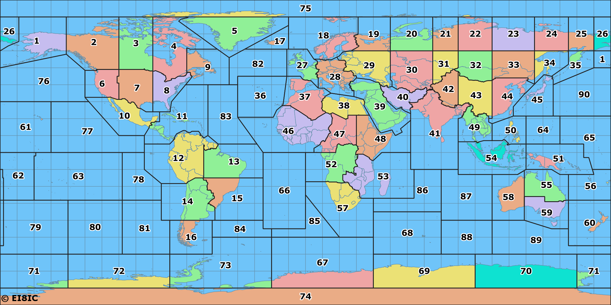
Click the map to see the full sized-version in a new browser-window.
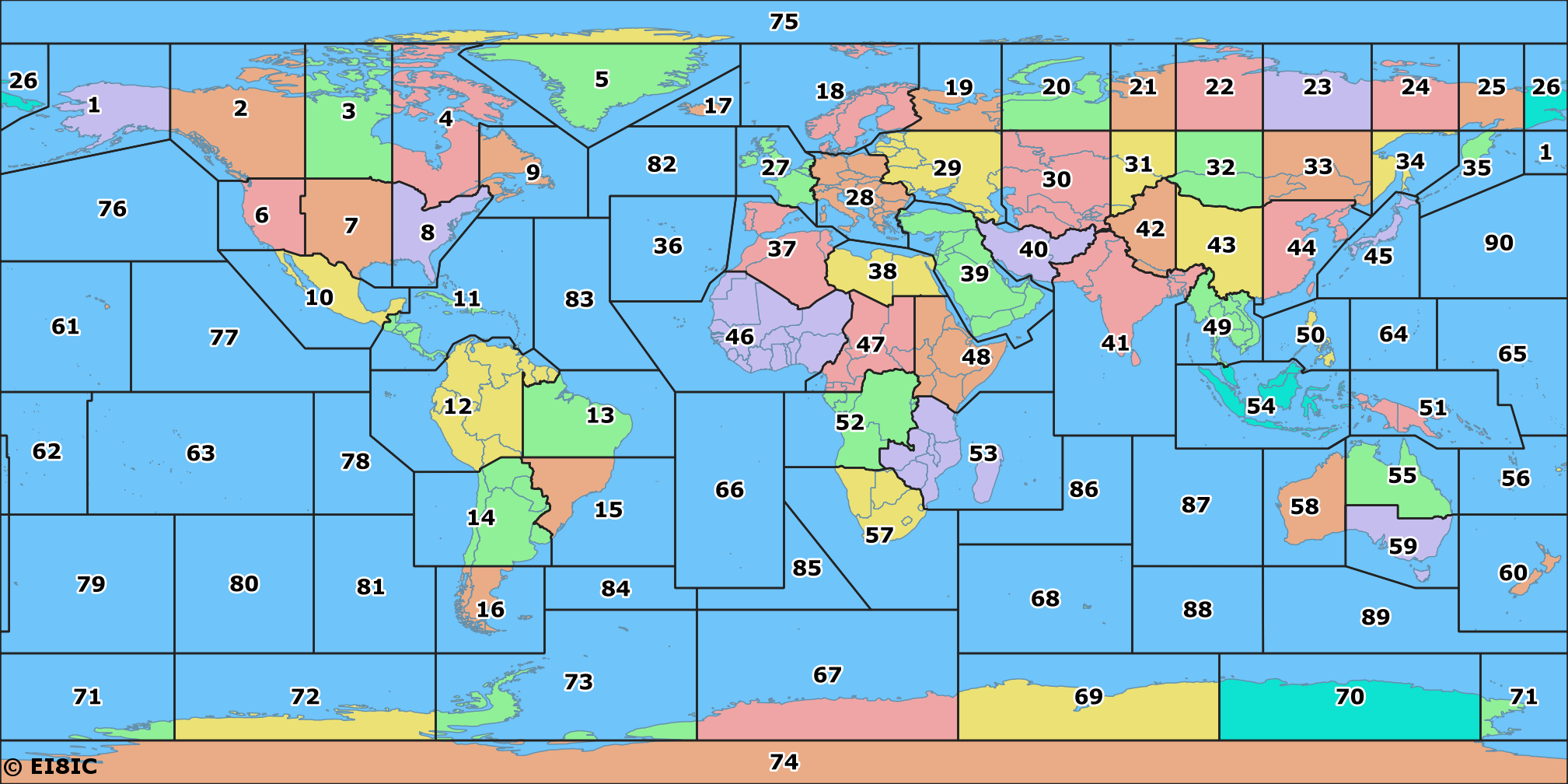
Click the map to see the full sized-version in a new browser-window.
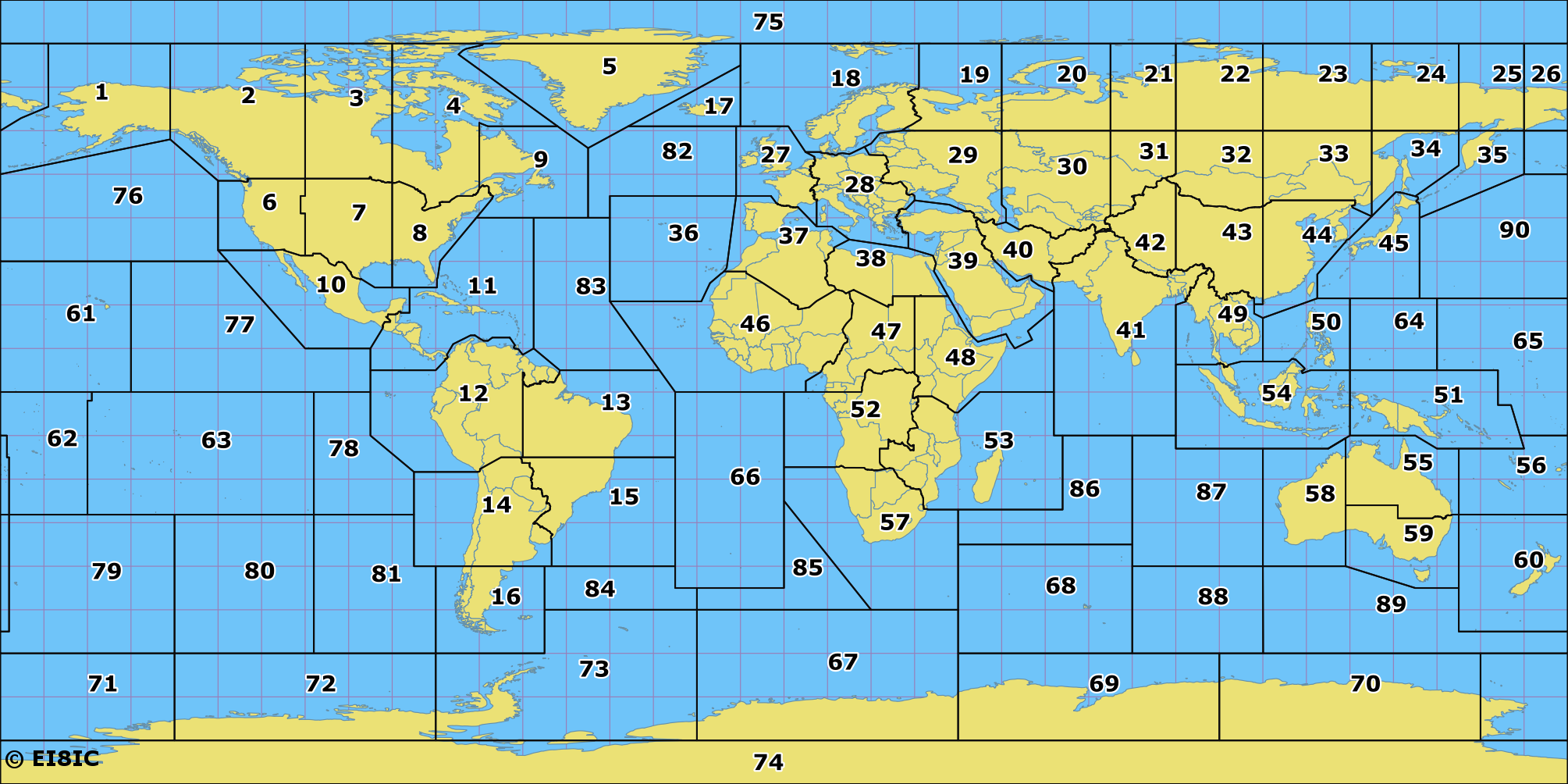
Click the map to see the full sized-version in a new browser-window.
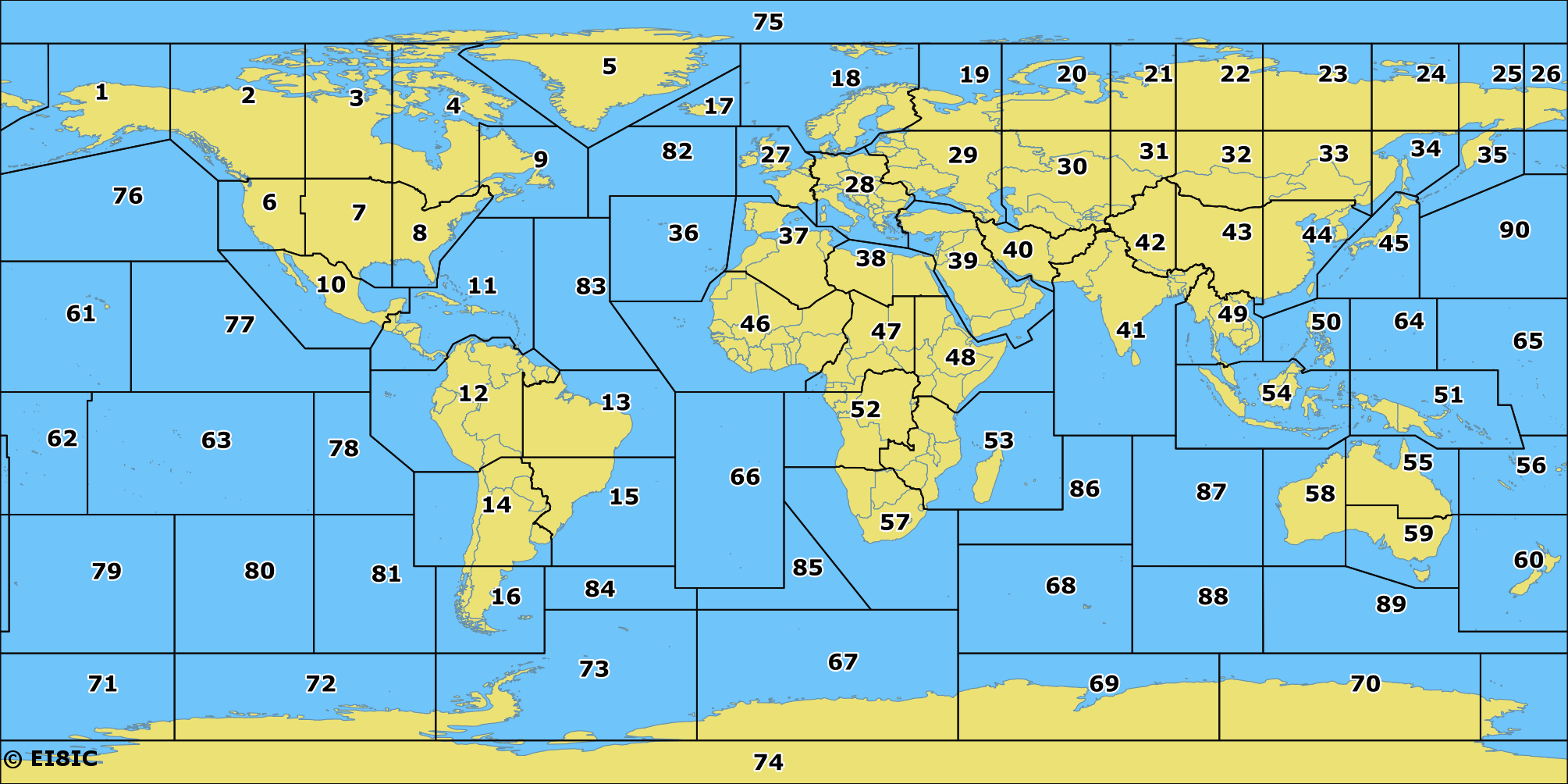
Click the map to see the full sized-version in a new browser-window.
If you don't live in London, Valencia, or Accra, and you would prefer world maps that are not always centered on the Greenwich Meridian at 0° longitude, then the latest version of the Global Overlay Mapper is for you. It produces seamless multi-overlay maps that are centered on any longitude. Here are two screenshots made from one of the twenty-three zoomable background maps, showing ITU Zones:
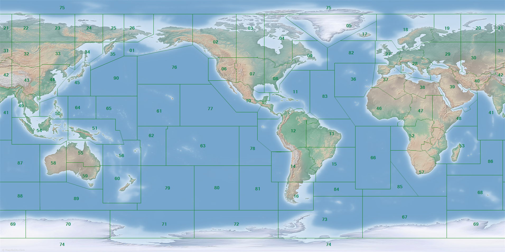
Click the map to see the full sized-version in a new browser-window.
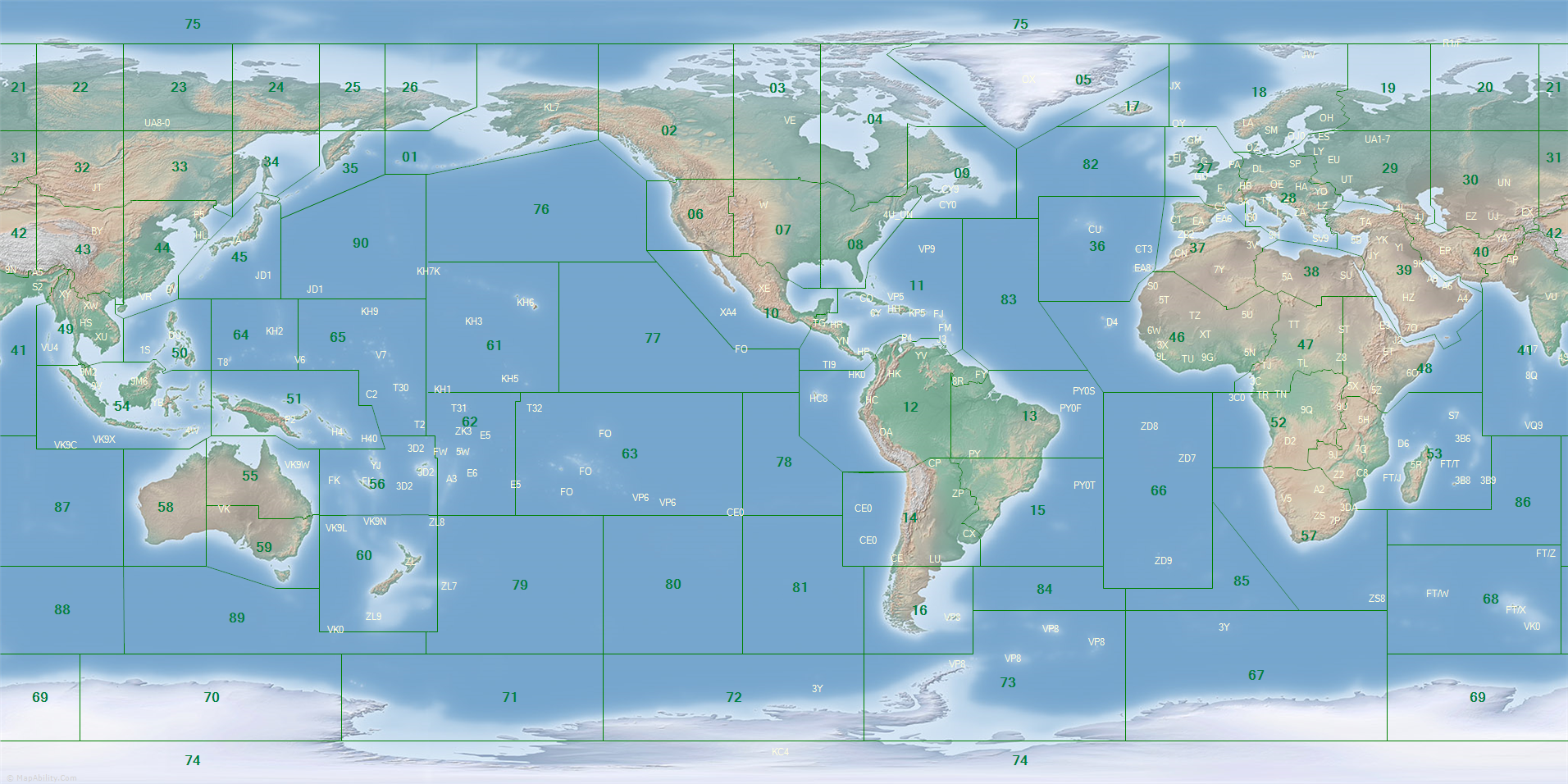
Click the map to see the full sized-version in a new browser-window.
If you use my maps, please buy me a coffee.
How much did you spend on your rigs and antennas? Buying me a coffee isn't much in comparison, is it?!
Some Background to the ITU Maps:
ITU zones originated from the professional 'CIRAF Zones' (Conferencia Internacional de Radiodifusion por Altas Frecuencias) which were defined at the 1947/1948 World Administrative Radio Conference, held in Mexico. They defined areas to be served by each shortwave broadcaster, and gave each CIRAF target zone a number. A current map of CIRAF Zones can be seen in REC. ITU-R SM.1413-41683.35CIRAF ZoneRDD ref: 0366 on page 464. Another page of interest, from 1999, is www.itu.int/net/ITU-R/terrestrial/broadcast/hf/refdata/maps/ but the viewer will quickly notice that many of the divisions are purely arbitrary, and do not follow the country-borders they are so obviously meant to represent. Surprisingly, this is still used as the 'Definition of ITU Zones' in the IARU HF Manager's Handbook (IARU Region 1) V9.0 June 2018 in Section 5:20 p.83. The reasons for this, as mentioned by Michael Keane, K1MK is that:
'The zones specified at that Mexico City conference are a set of latitude/longitude vertices which are connected by rhumb lines i.e., straight lines on a Mercator projection. The boundaries of these CIRAF zones do not follow any national borders (except by serendipity). That makes sense given that the purpose for defining these zones was to create a coarse grid for calculating HF coverage plots using propagation prediction programs of the day, the predecessors of what evolved to become VOACAP, etc.'
There are currently 85 ITU CIRAF zones, identified by Zone Number RDD ref: 0368; some of which may be divided into quadrants with a Quadrant Code RDD ref: 0367: for example, the North West quadrant of CIRAF Zone 14 would be identified as 14NW.
This was not so helpful for Radio Amateurs, so in 1996 a proposal was put to the IARU Region 1 Conference by the HF Committee of RSGB that common boundaries be identified and a common list be drawn up. This was then tabled at Lillehammer in 1999, then in Darwin, Region III in 2000 and then at the Region II meeting in 2001. At each of these meetings the paper (as originally drafted by John Forward, G3HTA, and based on the ITU CIRAF regions used in the broadcasting service) was accepted for use by the amateur radio service and approved by all Regions of IARU.
However, even today, the lists given by a number of major IARU member societies contradict each other, so you should be aware that conflicts might be noticed. In the search for a definitive list of ITU Zones, what you must remember first of all is that ITU CIRAF zones should not be confused with the ITU Zones as adapted for use by amateur radio operators in contests, and that secondly, any list of regions is normally composed of the countries represented, rather than precise zone borders, so therefore any lines across sea or ocean are generally representational, and should not be regarded as strictly definitive. As Larry E. Price W4RA, the IARU president in 2002, quoted on this page, says :
'You have to keep in mind that the ITU has one administrative purpose for having zones that has nothing at all to do with amateur radio. However, various amateur radio organizations decided to have both awards and operating events on the air based on the idea of zones. But, since this is not why the zones exist as far as ITU is concerned, the sponsors of these amateur events are free to interpret the zone boundaries any way they wish. So, there might not be a single "official amateur radio zone list." For the US & Canada, the interpretation by ARRL is found in The ARRL Operating Manual, desk top reference, page 12 which defines the boundaries between US States and Canadian provinces. If you have more questions about any particular contest or award, they should be directed to the sponsor.'
In other words, each contest-organizer or award-manager can define zones as whatever they choose, and it is up to the operator to check with the organizer of the contest or award that they are interested in.
The Radio Society Of Great Britain (RSGB) website has a useful list which defines some geographical borders, where that border is important, but leaves the definition of many based solely on the containing countries.
In 2021, the ARRL contest page includes a list of the ITU Zone Border Definitions for the US and Canada, and that list differs from the RSGB list when defining the borders for Zones 06, 07, 08: essentially these borders are listed at 110W and 90W, rather than using the State borders. They do not include an ITU Zone map of their own: instead there is a link that points to this page, so I guess they like what I do.
Surprisingly, the IARU HF World Championship Webpage doesn't even make any comments about zone lists or their borders, but refers you back to the ARRL website.
Final comments: the information currently used for the ITU Zone maps on the MapAbility.Com website is believed to be the most accurate of any presently available.
|